YASC 2023 Award of Excellence Recipient
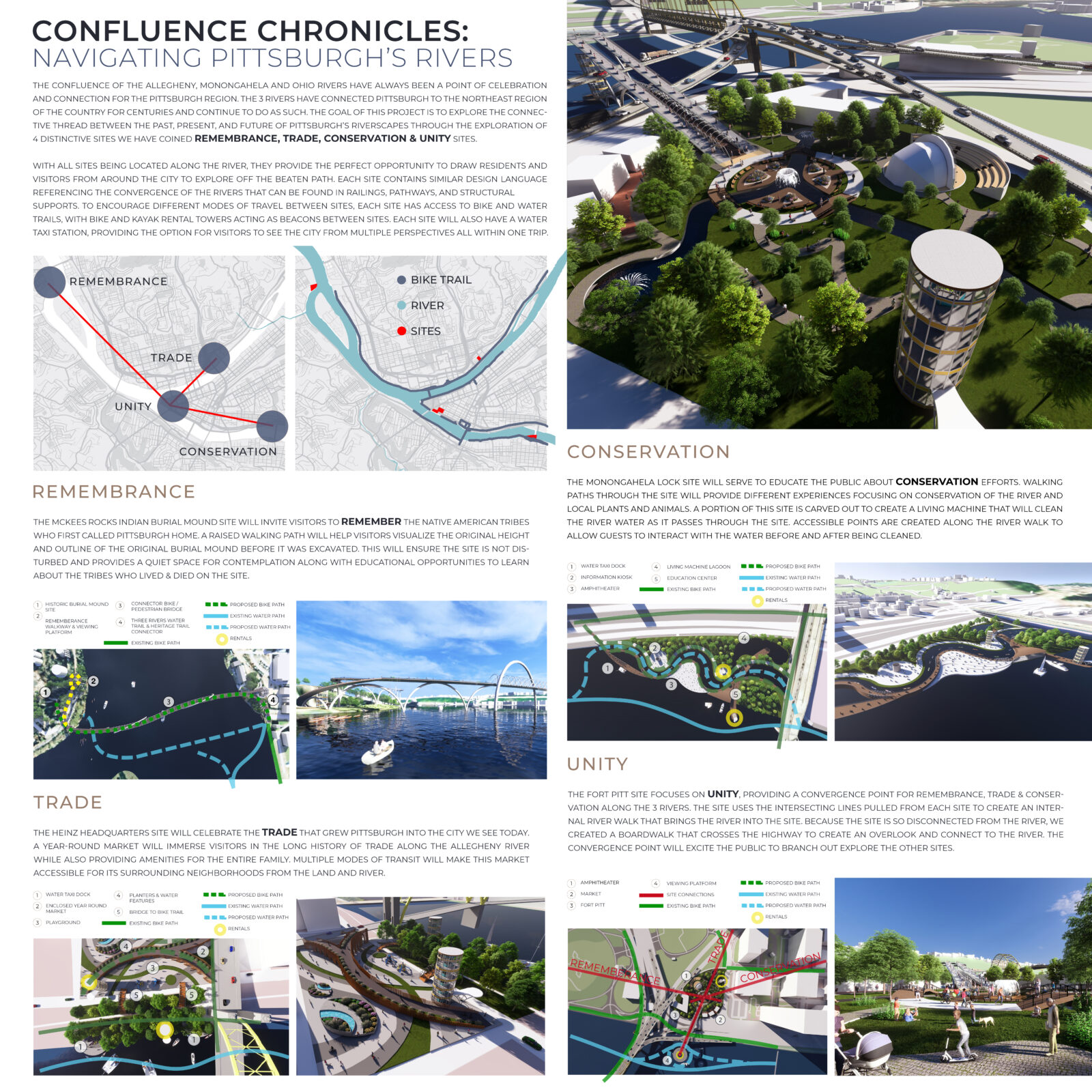
Confluence Chronicles: Navigating Pittsburgh’s Rivers
Sanzinia Nevarez Cardenas; Samantha Clark; Nikita Williamson; Lindsey Reynolds; Cornelius Pace; Fabian Carrazana
LGA Partners
The confluence of the Allegheny, Monongahela and Ohio rivers have always been a point of celebration and connection for the Pittsburgh region. The 3 rivers have connected Pittsburgh to the Northeast region of the country for centuries and continue to do as such. The goal of this project is to explore the connective thread between the past, present, and future of Pittsburgh’s riverscapes through the exploration of 4 distinctive sites we have coined Remembrance, Trade, Conservation & Unity Sites.
The McKees Rocks Indian burial mound site will invite visitors to remember the native American tribes who first called Pittsburgh home. A raised walking path will help visitors visualize the original height and outline of the original burial mound before it was excavated. This will ensure the site is not disturbed and provides a quiet space for contemplation along with educational opportunities to learn about the tribes who lived & died on the site.
The Heinz Headquarters site will celebrate the trade that grew Pittsburgh into the city we see today. A year-round market will immerse visitors in the long history of trade along the Allegheny River while also providing amenities for the entire family. Multiple modes of transit will make this market accessible for its surrounding neighborhoods from the land and river.
The Monongahela Lock site will serve to educate the public about conservation efforts. Walking paths through the site will provide different experiences focusing on conservation of the river and local plants and animals. A portion of this site is carved out to create a living machine that will clean the river water as it passes through the site. Accessible points are created along the river walk to allow guests to interact with the water before and after being cleaned.
The Fort Pitt site focuses on unity, providing a convergence point for Remembrance, Trade & Conservation along the 3 rivers. The site uses the intersecting lines pulled from each site to create an internal river walk that brings the river into the site. Because the site is so disconnected from the river, we created a boardwalk that crosses the highway to create an overlook and connect to the river. The convergence point will excite the public to branch out explore the other sites.
With all sites being located along the river, they provide the perfect opportunity to draw residents and visitors from around the city to explore off the beaten path. Each site contains similar design language referencing the convergence of the rivers that can be found in railings, pathways, and structural supports. To encourage different modes of travel between sites, each site has access to bike and water trails, with bike and kayak rental towers acting as beacons between sites. Each site will also have a water taxi station, providing the option for visitors to see the city from multiple perspectives all within one trip.
JURY COMMENTS: The jury found this entry particularly notable for its impressive degree of modeling, problem solving, and comprehensive approach to design solutions for all four sites. This entry managed to successfully address all three scales that are critical for the communication of place and for design proposals to solve—the small, medium, and large scale. The entry is so successful that the jury felt that each site can be broken out as standalone entries and still be maintained as a convincing design solution. The raised bridge proposed for the McKees Rocks site not only provides for a unique way to experience this site but also solves an accessibility issue inherent to this location. The constructive criticism provided during the discussions was that there were almost too many decisions per inch of board space and that perhaps some of the graphics could have been toned back into rudimentary diagrams or sketchy concepts to show more process. Overall, this was viewed as a compelling entry and notable for thoughts, effort, and vision set forth.
Honorable Mention
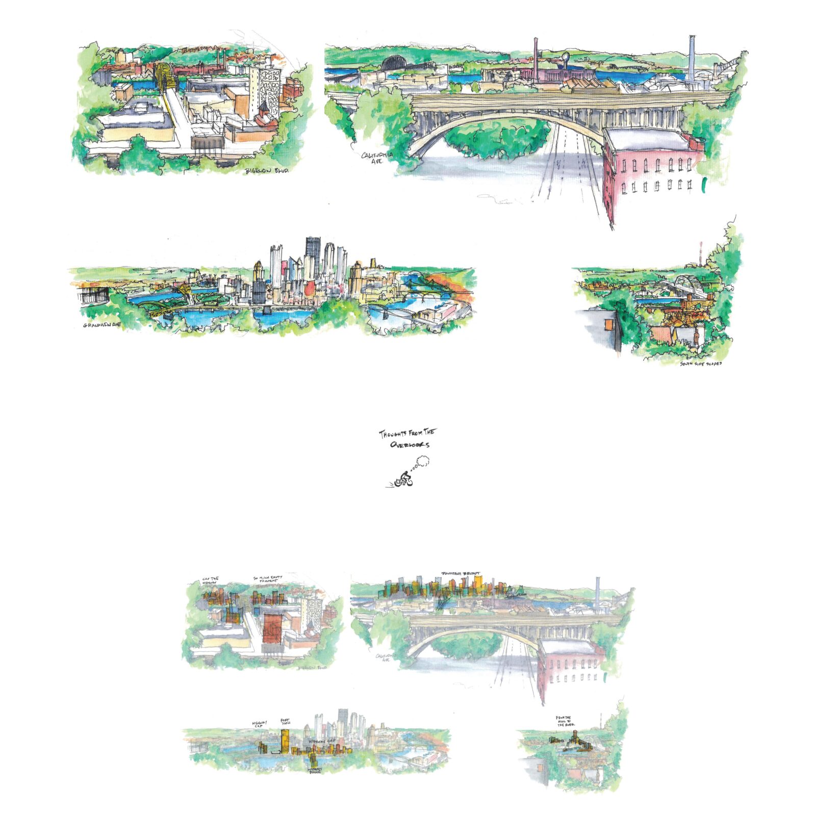
Thoughts From the Overlooks
Walter Haim, Assoc. AIA
Rothschild Doyno Collaborative
A beautiful weekend, bicycling to different overlooks, sketching, swatting spotted lanternflies, appreciating what is, imagining what could be, taking in the last of summer, the first of fall.
JURY COMMENTS: The jury found this entry intriguing in the minimalism rendered with hand sketches and abundant white space. There are many suggestive and provocative ideas contained in the graphics and the jury was impressed with the use of the process-oriented rendering style. The ideas need more development and do not adequately address the three scales of design communication, but they speak to the magic of a pen and paper as well at the big ideas that architects and designers bring to the table.
FLOWing through the river past, present, and future
Seyoung Choo
Carnegie Mellon University
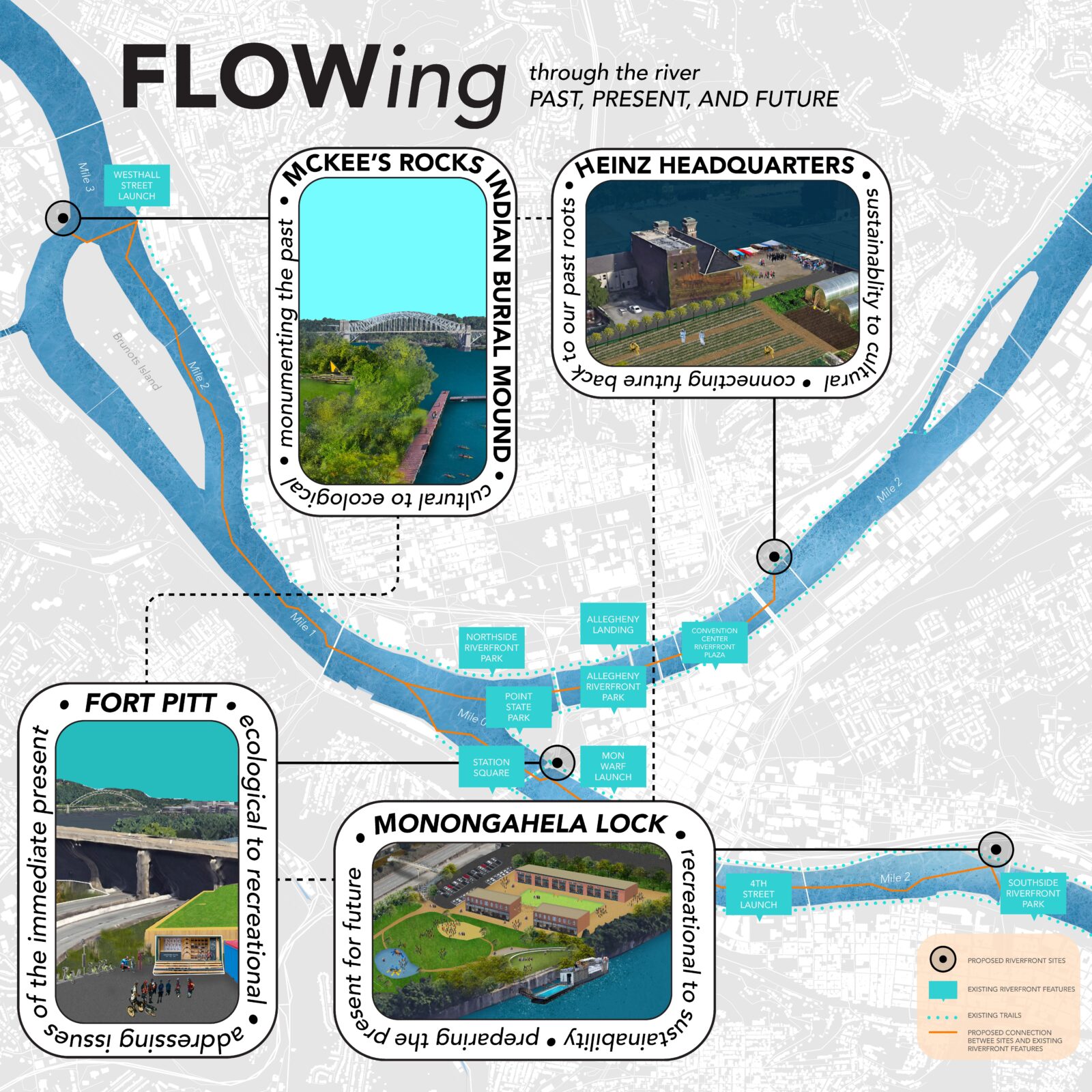
Similar to the merging of Pittsburgh’s three rivers, the FLOWing project aims to establish connections among four distinct sites on various scales, with diverse impacts and layers. These four sites – McKee’s Rocks Indian Burial Mound, Fort Pitt, Monongahela Lock 1, and Heinz Headquarters – though geographically separated, are seamlessly integrated into the existing riverfront infrastructure, encompassing docks, community spaces, and trails accessible by both water and land transportation networks. This integration transforms each site from mere nodes into components of an interconnected corridor within our community. Each of these four sites is structured to focus on one primary design theme, supported by an additional design aspect. These themes encompass culture, ecology, recreation, and sustainability, and they are translated into specific functions and programs at each location. The supporting elements ensure a cohesive sequence among the multiple sites while maintaining their individual, unique purposes.
The McKee’s Rocks Indian Burial Mound holds immense historical and symbolic significance for the community, representing indigenous values of nature respect, and stewardship. Situated in close proximity to Stowe Township’s various ethnic community spaces, Brunots Island, and Westhall Street Launch, it offers a unique opportunity to serve as a hub for integrating the rich cultural and historical heritage while coexisting harmoniously with the native ecology. Project FLOWing envisions the transformation of this site into a cultural amphitheater and meditation garden, designed to host community-led activities and interpretive outdoor art exhibits that pay homage to the land’s history and engage the community. Additionally, the project proposes the construction of a new fishing and kayak dock, facilitating interaction with nature in traditional indigenous ways and both recreationally in which the activity can extend to Brunots Island, contributing to the enhancement of its biodiversity.
The Fort Pitt site is divided into two distinct sections: a small southwestern portion dictated by the bridge infrastructure’s geometry and a northeastern area adjacent to the original Fort Pitt blueprints, currently serving as a parking lot. This project site aims to extend ecological connectivity from the previous site while creating a prominent recreational node that links to our community’s extensive trail system. Project FLOWing at this site addresses pressing issues within our built environment, focusing on minimizing pollution and the negative environmental impacts associated with bridge pavement and parking lots. The southwestern section, despite its limited accessibility, will be dedicated to ecosystem restoration. It will feature a mix of aquatic and wetland vegetation capable of providing habitat for aquatic life, filtering polluted water, and capturing debris from the roads that would otherwise enter the water. Conversely, the northeastern portion of the site will serve Point State Park and the Three Rivers Heritage Trail by offering a space for bike repair and community engagement.
The site at Monongahela Lock 1 will serve as a prominent hub for recreation and transportation, providing efficient and accessible transportation options for the community while fostering a multifunctional and economically sustainable system through commercial development. Additionally, it will serve as a vital link to the GAP trail via a newly constructed pedestrian bridge over the highway. This will not only improve access to water travel over traditional transportation modes but also create new community and commercial spaces characterized by energy-efficient architecture and local food sourcing. These innovations aim to encourage community engagement and promote a sustainable future.
Lastly, the Heinz Headquarters site offers an experimental opportunity to celebrate our community’s innovative character and history. Pollution or brownfield areas will be remediated using environmentally friendly and natural methods, and repurposed for community agriculture and food sourcing. This location envisions cutting-edge research in innovative agricultural systems and technologies.
Recharge City
Sarah Connors, Assoc. AIA
Hasenstab Architects
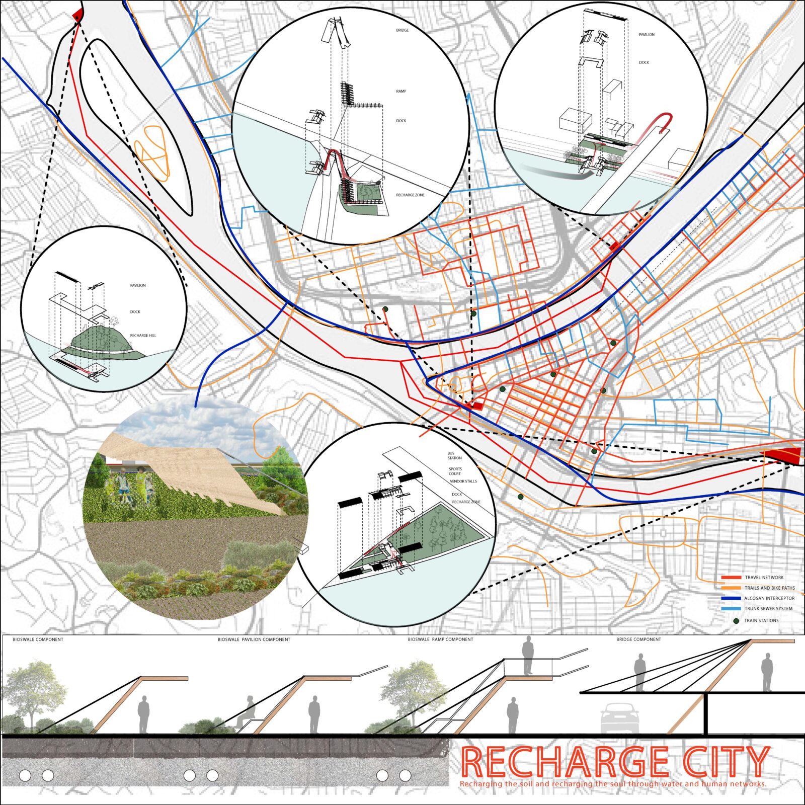
The rivers and the river’s edge are an important consideration within the urban landscape. Currently there are water networks throughout the city that are not benefiting people or the water’s health. The river’s edge plays an important role in channeling water to prevent run off, or overflowing sewer systems.
The collection of precipitation through Bioswales is a natural way filter water. The soil recharging components are made from heavy timber and steel wire referencing not only our industrial past but also our connection with our roots and future. This component acts as a collector, funneling water into a bioswale system below. The water collects and filters through native plants or permeable paving allowing the soil to recharge the landscape. This can help to prevent runoff as well as improve soil health. The excess water will filter through the gravel and into pipes that transfer it for further cleaning. This also helps prevent sewer overflow which can damage the water quality in the river.
Using the waterways to travel would change the way we interact with the city. These terminals allow for public transportation and pedestrian connection to the rest of the city. With bus lines, train stations, and attractions within a walkable distance, people can use these terminals for travel or as their destination. The rivers can also be used for recreational travel such as kayaking or paddle boarding with several areas to stop along the river’s edge. By repeating the soil recharging component, they can be used as pavilions, ramps and bridges to allow people to enjoy the park as it recharges the soil. The repetition of the same component acts as a landmark for people using their boats or knowing where to catch the ferry.
All four sites offer an area to rest, meet new people, hold events, and exercise. The McKees Rocks site is a Native American burial ground. By leaving the land to restore in peace, residents can use a boardwalk in the water to reflect and relax in their surroundings. The Point is a pivotal part of the city, and the history of the fort is at the very foundation of the city. The new soil recharging park can be enjoyed from an elevated platform using a ramp that references the angles of the fort. The Monongahela Lock used to be an integral part of river travel in the city. Leaving much of the land to promote an ecological haven, residents can walk along the river’s edge as well as space for large events, activities and sports. Heinz Headquarters is along the Heritage path and near the historic Heinz Complex. By keeping the heritage path intact and creating a recharging zone in the rest of the site, it draws people off the path to continue to explore.
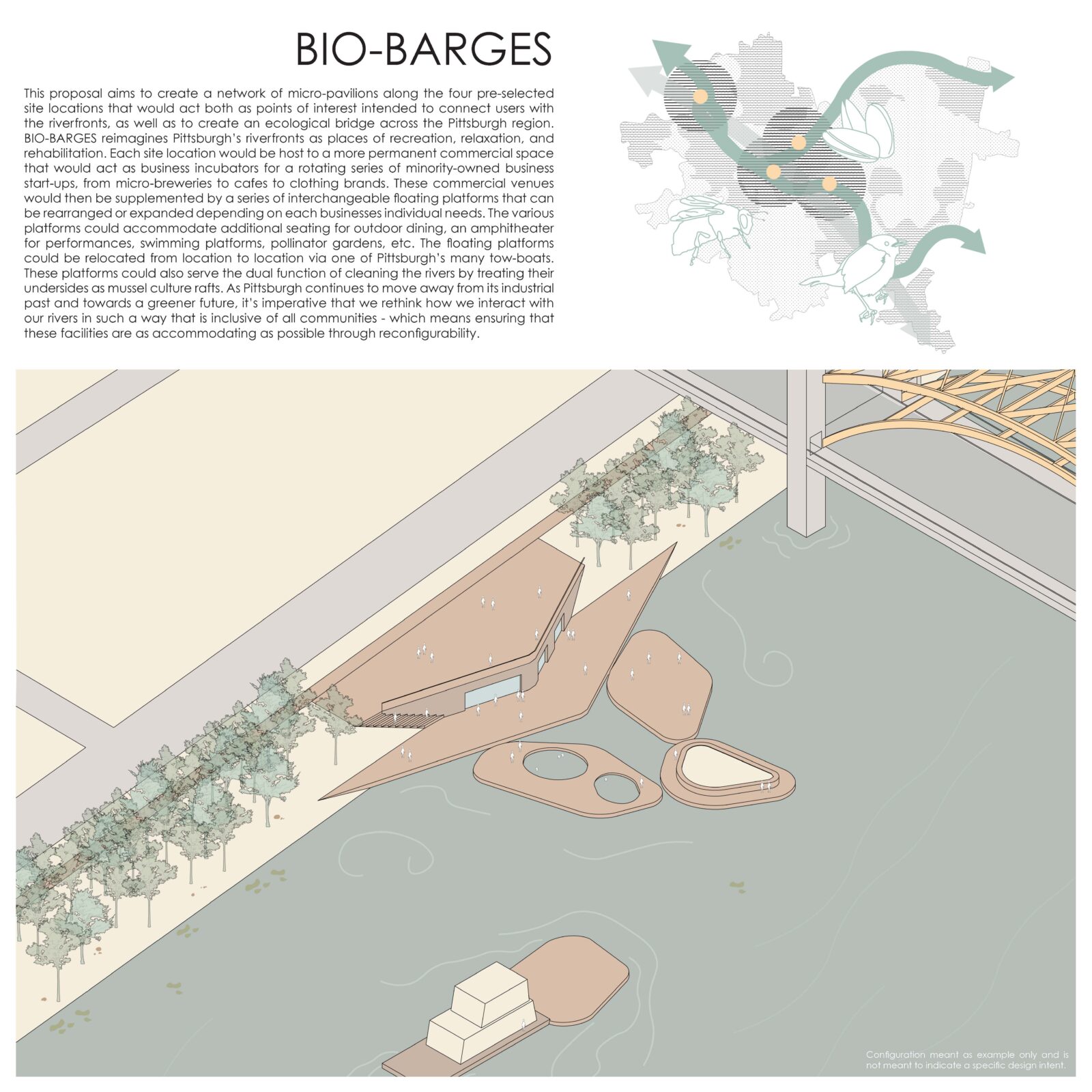
BIO-BARGES
Joshua Jordan
This proposal aims to create a network of micro-pavilions along the four pre-selected site locations that would act both as points of interest intended to connect users with the riverfronts, as well as to create an ecological bridge across the Pittsburgh region. BIO-BARGES reimagines Pittsburgh’s riverfronts as places of recreation, relaxation, and rehabilitation. Each site location would be host to a more permanent commercial space that would act as business incubators for a rotating series of minority-owned business start-ups, from micro-breweries to cafes to clothing brands.
These commercial venues would then be supplemented by a series of interchangeable floating platforms that can be rearranged or expanded depending on each businesses individual needs. The various platforms could accommodate additional seating for outdoor dining, an amphitheater for performances, swimming platforms, pollinator gardens, etc. The floating platforms could be relocated from location to location via one of Pittsburgh’s many tow-boats. These platforms could also serve the dual function of cleaning the rivers by treating their undersides as mussel culture rafts.
As Pittsburgh continues to move away from its industrial past and towards a greener future, it’s imperative that we rethink how we interact with our rivers in such a way that is inclusive of all communities – which means ensuring that these facilities are as accommodating as possible through reconfigurability.
These platforms were inspired by imagery of tow-boats pushing barges full of coal up and down the rivers, as these boats are such an iconic part of the city’s identity that it would be a shame to lose them completely in a world where Pittsburgh doesn’t have any remaining steel mills.
Integral to the success of this proposal would be the inclusion of native plantings to create an ecological bridge between the area’s existing greenways in order to help further reinforce the restorative intent of the projects it relates to local wildlife. There would be opportunities to provide food and habitat for things as generic as bees and butterflies to more specific species such as the endangered Sedge Wren or Yellow-Crowned Night Heron.
While the primary graphic used site #4 as a canvas, each pavilion would be tailored to best fit its context and site. This proposal is less of a specific architectural proposal meant to suggest a specific style or formal intent as it is a framework for an idea.
Our Riverfront Resilience
Courtney Singley, Assoc. AIA
Stantec
Water has shaped Pittsburgh long before humans gave it a name.
The rivers drew many different peoples from Native American tribes, such as the Lenape and Shawnee, to European settlers. Throughout the city’s history, the Monongahela, Allegheny, and Ohio were vital to travel, trade, living, and industry.
However, over the past centuries, industry has had the dominant hold over river use in Pittsburgh. The ease of shipping and use of water as a means for manufacturing has left the city’s connection to the rivers one-sided. The rivers get used – they do not get protected nor celebrated. The abundance of bridges might as well suggest that rivers are, for the average resident, something to “get over” and be done with.
It is time for the city to remember the importance of the rivers, and to bring them back into the cultural fold. In doing so, it is critical to educate the public about the process that got us to this state. Industry has severed people’s connections with the water – but it also will shape our ever-evolving relationship with water moving into the future.
As a former industrial city, we cannot forget our involvement in the degradation of land, natural resources, and communities that industry has spurred. While our city will be less prone to extreme weather conditions such as wildfire, hurricanes, and droughts, Pittsburgh will be at great risk for flooding and landslides in addition to higher temperatures.
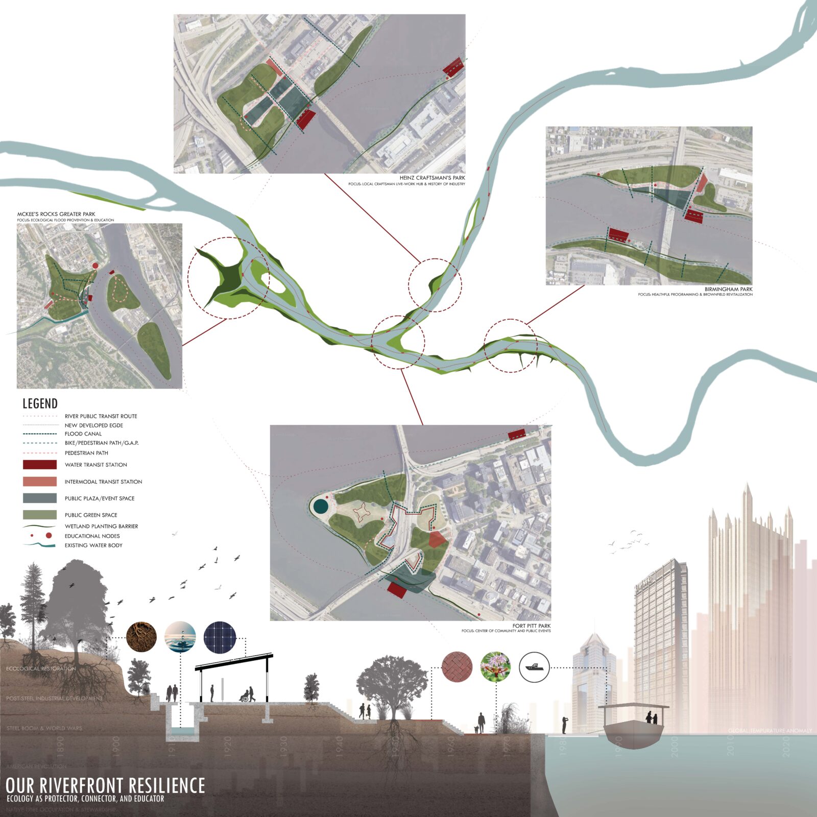
For this reason, our Riverfront should be regarded as our greatest source of resilience in protecting, connecting, and educating our people and communities. With the integration of thoughtful ecological and infrastructural design, we can become a leader in post-industrial transformation that responds to the impending climate crisis.
Fort Pitt Park is the central hub of the park system and connects to the Golden Triangle of downtown. It aims to educate (as located by the education nodes) the public on upcoming events, the history of the nearby forts and river travel. The south of the site formerly hosted the Monongahela Wharf, a site of public ferry systems in the past.
Heinz Craftsman’s Park celebrates the history of industry and trades of Pittsburgh. Historic maps indicate that this area was home to wood mills and craftsman, and had street names based on tree species, only of which “Chestnut Street” remains. In addition to the educational nodes here, the space will house live-work units for local craftsman where they can educate the public and operate small businesses.
Birmingham Park focuses on connecting with the existing bike network of the Great Allegheny Passage and with the ongoing waterfront development of the South Side. The educational nodes here will also serve to educate the public on healthful living and the city’s efforts to revitalize brownfields such as this site, a current concrete plant.
McKee’s Rocks Greater Park is primarily a green park designed to strongly mitigate the flooding of the surrounding community. A memorial and educational center serves the former site of the nearby Native American Burial Mound.